SOME HIGHLIGHTS FROM QUAGGA (2)
Thank you for the wonderful response to our emailer last month. We have highlighted some interesting new stock below. Please have a look at our website for more.
“CUT INTO LITTLE BITS”
“If the country is cut into little bits we should die of starvation. We are headmen for the Government, and what should we have to look after if the country were cut into little bits. Individual tenure is like a man with one wife, when his solitary wife dies what is the good of him.”
(Testimony of headman Tetyana of Idutywa. Government Commission on Native Laws and Customs 1881 – 1883).
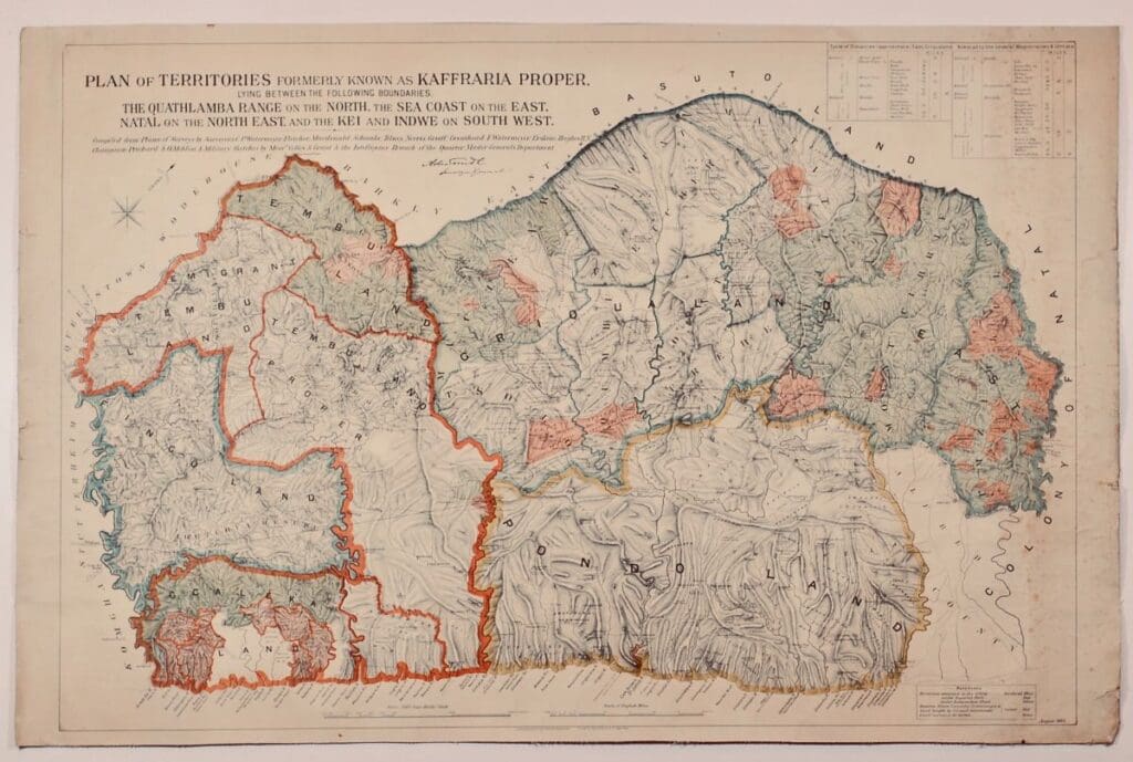
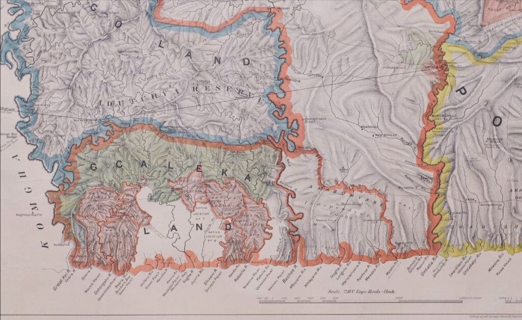
An exceptionally rare map showing British Kaffraria Proper (as opposed to British Kaffraria – the districts of King Williams Town and East London annexed to the Cape Colony in 1865). All the remaining Xhosa territory beyond the Kei River, south of the Drakensberg and as far as the Natal frontier remained independent for longer and was known as Kaffraria Proper.
Titled: Plan of the Territories formerly known as Kaffraria Proper lying between the following boundaries ,The Quatlamba Range on the North, the Sea Coast on the East, Natal on the North East and the Kei and the Indwe on (the) South West.
Dated: August 1884 and signed in the lithograph by the Surveyor General of the Cape Colony, Abraham de Smit. Coloured lithograph laid down on linen. Printed by Saul Soloman.
Dimentions: 66 x 100cm
The Reference Key Indicates:
- Territories annexed to the Colony
- Territories under Imperial Rule
- Territories under Independant Chiefs
- Reserves, Native Locations, Commonages and land bought by the Colonial Government
- Land Surveyed for Farms
- Trading Stations indicated with the name of the trader in most cases
- Kraals with the name of the Chief
- Magistracies
- Outlying Mission Stations
- Outlying Schools and Churches
- Numerous topographical details
The dissatisfaction of the Cape Colonial Government with the limited order possible in the semi-autonomous regions of the area east of the Kei led to abortive attempts for survey and subdivision in the area between 1878 and 1884.
An attempt to re-engineer the existing communally managed areas into small freehold lots was made. However, things didn’t go the way the Cape Government intended and local people fended off pressure for survey and title.
“Social engineering also spoke directly to the geographical science of the surveyor and the evolving ethnographic fixations of magistrates, who worked with missionaries and headmen alike to realise schemes for managing these areas’ administration in the name of progress and industry as well as economy. Mission stations, schools, and cultural practices in these new spaces, and played early roles in this spacial imposition. “(Colonial Survey and Native Landscapes in Rural South Africa, 1850-1913 by Lindsay Frederich Braun.)
De Smidt’s map is a graphic record of the tapestry created by the colonial government in its attempt to create a manageable territory.
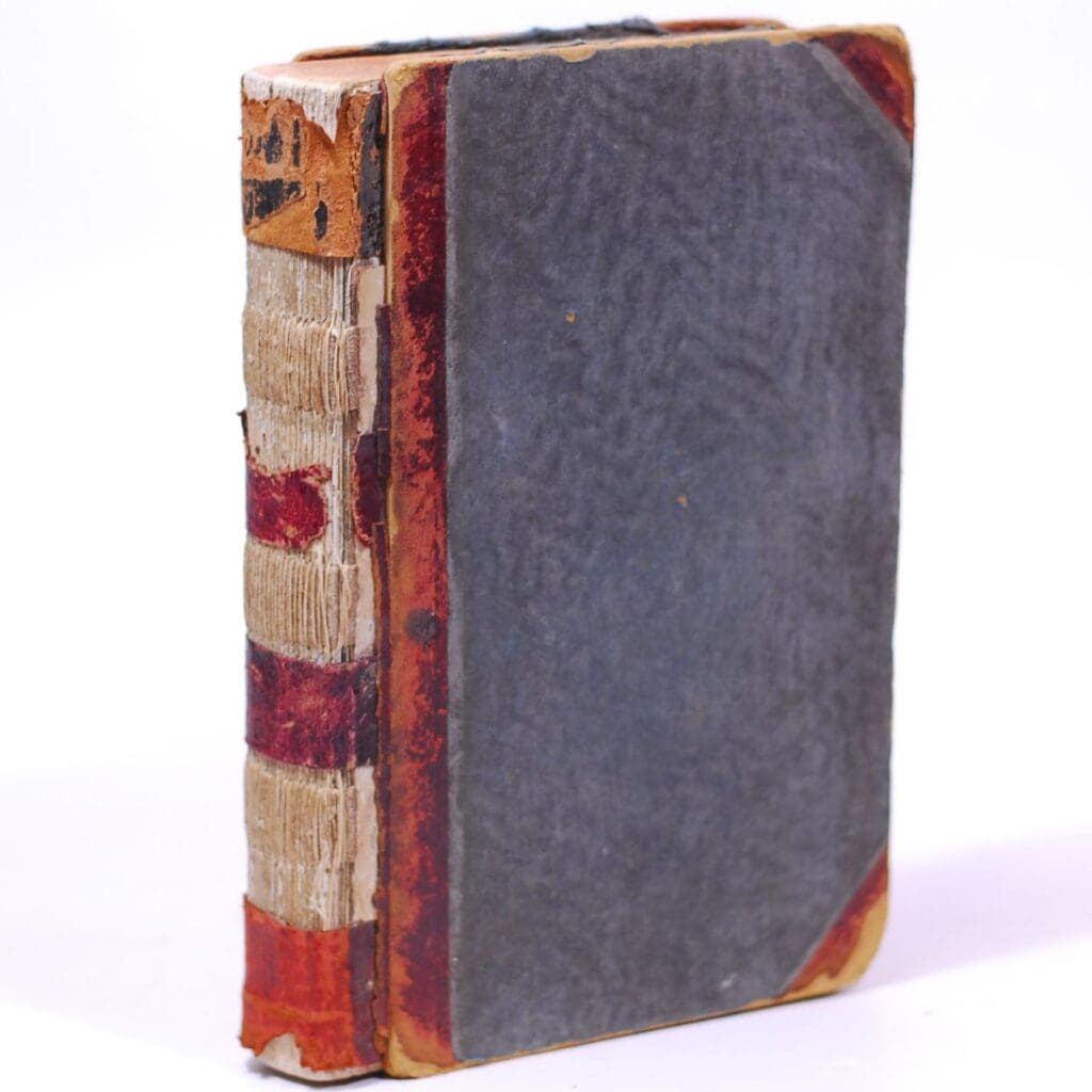
A NATIVE COMMISSIONER’S MINUTE BOOK
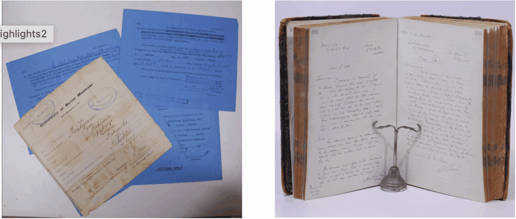
This book deals with a series of cases of family law. It is a document showing how the British Colonial Empire tried to control the day to day minutiae of African life in then Rhodesia.
Part of an index is present, but some pages are missing. There are in excess of 300 cases over 558 pages of hand written text, from 1912 to 1917. The cases were heard in the village of Magunda in the Buhera district in the Manicaland Province of Eastern Rhodesia.
Most cases deal with family disputes, usually centred around cattle and labola. Some involve children, estranged wives and adultery. Usually the defendant states his case, followed by the plaintive, followed by a brief judgement. The claim is usually for livestock.
Each case is signed by the attending Assistant Native Commissioner (ANC), who wrote the minutes. There are three who deal with the cases in this volume.
The first is A.H.Bowker. A former naval captain who became a career officer in Southern Rhodesia’s Native Affairs Department from around 1903. He later became Chief Clerk to the Chief Native Commissioner in Salisbury. He retired in the 1930’s and became the harbourmaster at Simonstown.
These entries are followed by those of Cecil Frank Molyneux who was an acting Assistant Native Commissioner form 23/8/1913 to 15/09/1913. Born in 1879 he is listed as a trooper in the Natal Carbineers and was present during the Siege of Ladysmith. He later became a Magistrate and Native Commissioner with the British South African Company (BSAC) in Northern Rhodesia.
Lastly there are the entries of John Lindsay Oliver. Assistant Native Commissioner 12/02/1916 to 11/05/1917. He later became District Commissioner at Mwera, Southern Rhodesia and was on the King’s Birthday List to reward and highlight good work by citizens abroad.
There are also four permits for natives to carry arms and ammunition loosely inserted into the book together with “Certificate of Native Marriage”.
Native Commissioners were representatives of The British South Africa Company (BSAC or BSACo). Chartered in 1889 following the amalgamation of Cecil Rhodes’ Central Search Association and the London-based Exploring Company Ltd, which had originally competed to capitalise on the expected mineral wealth of Mashonaland but united because of common economic interests and to secure British government backing. The company received a Royal Charter modelled on that of the British East India Company. Its first directors included The 2nd Duke of Abercorn, Rhodes and the South African financier Alfred Beit. Rhodes hoped BSAC would promote colonisation and economic exploitation across much of south-central Africa, as part of the “Scramble for Africa”. However, his main focus was south of the Zambezi, in Mashonaland and the coastal areas to its east, from which he believed the Portuguese could be removed by payment or force, and in the Transvaal, which he hoped would return to British control.
It has been suggested that Rhodes’ ambition was to create a zone of British commercial and political influence from “Cape to Cairo”, but this was far beyond the resources of any commercial company to achieve and would not have given investors the financial returns they expected. The BSAC was created in the expectation that the gold fields of Mashonaland would provide funds for the development of other areas of Central Africa, including the mineral wealth of Katanga. When the expected wealth of Mashonaland did not materialise and Katanga was acquired by the Congo Free State, the company had little money left for significant development after building railways, particularly in areas north of the Zambezi. BSAC regarded its lands north of the Zambezi as territory to be held as cheaply as possible for future, rather than immediate, exploitation.
As part of administering Southern Rhodesia until 1923 and Northern Rhodesia until 1924, the BSAC formed what were originally paramilitary forces, but which later included normal police functions. In addition to the administration of Southern and Northern Rhodesia, the BSAC claimed extensive landholdings and mineral rights in both the Rhodesias and, although its land claims in Southern Rhodesia were nullified in 1918, its land rights in Northern Rhodesia and its mineral rights in Southern Rhodesia had to be bought out in 1924 and 1933 respectively, and its mineral rights in Northern Rhodesia lasted until 1964. The BSAC also created the Rhodesian railway system and owned the railways there until 1947. (Wikipedia)
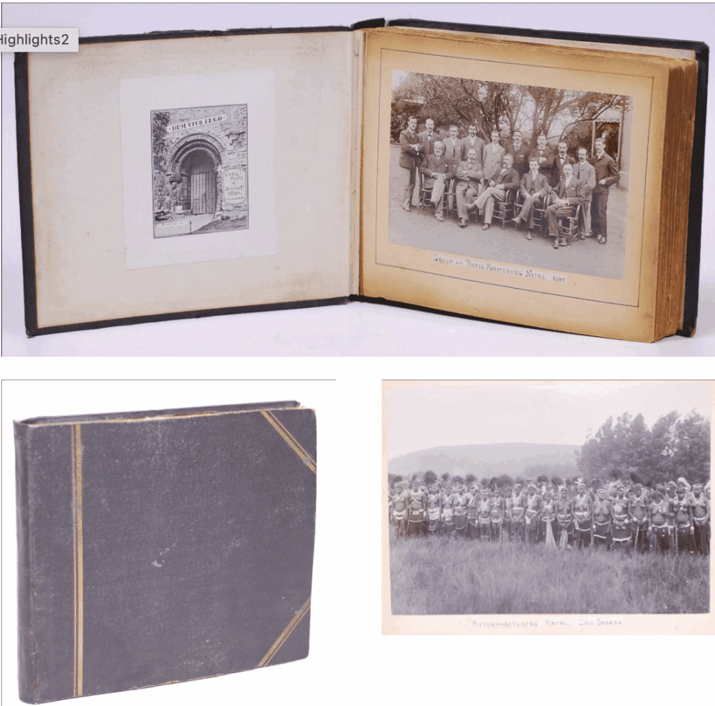
PHOTOGRAPH ALBUM – NATAL AND BOER WAR INTEREST
Photograph album of Ernest C.D. Wire, son of Alfred Philip Wire, teacher, photographer and noted naturalist. Alfred’s bookplate is at the front paste down.
Ernest appears to have been a primary school teacher in Pietermaritzburg in 1902. The album contains a total of 110 photographs. Twenty-four are full page – 20 x 13.5cm of which fourteen are collotypes. The remaining ten are albumen prints. There are eighty six smaller (between 9.5 x 7.5 and 11 x 8.5) albumen prints.
Most appear to have been taken by Wire and a number of others appear to be purchased photographs.
Images of Pietermaritzburg, Albert and Howick falls. The 1902 sea crossing on “Umsinga” with a view of Las Palmas along the way. A 1902 view of Durban from the Berea, fourteen collotype prints of rickshaw drivers, government buildings, Durban and Pietermaritzburg, the Bluff etc.
Two full page images of the Duke and Duchess of York’s visit in 1901 and numerous other images documenting Durban and Pietermaritzburg areas.
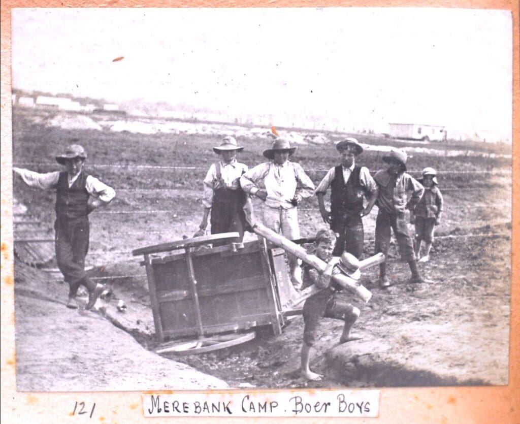
A number of images of a survey party and of the breakwater at Port Shepstone. There are six images of Merebank Concentration Camp which incorporated Windermere, Hazelmere and Grasmere. Images of children at the camp and of their school room, also one of the “Africander Store”.
The history of Merebank is fraught with contradictions, one being the large salaries that were offered to British teachers to work at the camp. The schools were however short on desks, books, blackboards and other teaching necessities. The Boers made some attempt to start their own schools, less vulnerable to imperial propaganda, but these were swiftly forbidden.
There is no evidence of Ernest Wire teaching at the camp, though he may have done so. There are also images of the tin buildings that were unique to Merebank. Due to the sub-tropical climate of Natal, the bell tents used in the camps of the Transvaal were not suitable. These buildings however lead to problems of their own. Fleas, lice and mosquitoes were a plague and privacy became a great issue. (A.U. Wohlberg – The Merebank Concentration Camp in Durban 1901-1902 MA Thesis.)
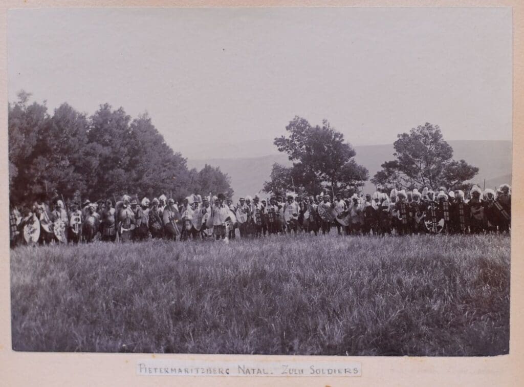
There are also two striking full-page prints of a “Zulu Indaba” showing mostly Zulu women and of “Zulu Soldiers” in full battle regalia.
One image of Chamberlain’s Reception in Pietermaritzburg, followed by what appears to be a tour of Anglo-Boer War battle sights in 1903. Ladysmith, Spion Kop, Wagon Hill, Caesar’s Camp and Col. Cunyngham’s grave. Images of the boys drilling at the Pietermaritzburg Model School and others
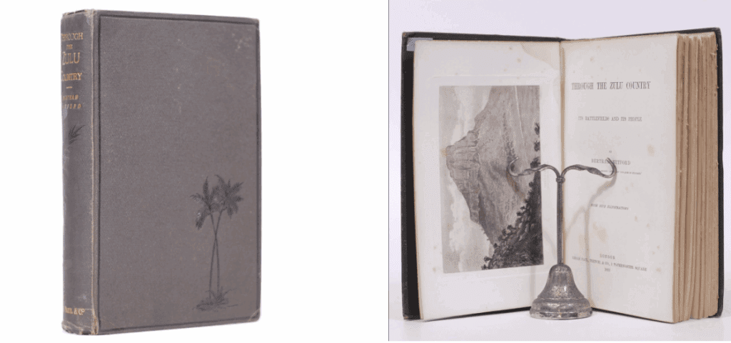
THROUGH THE ZULU COUNTRY
An account of a trip through Zululand, undertaken in 1882, with the special object of visiting its battlefields and studying the character and social position of its inhabitants, “gathering their opinion on the subject of the recent campaign and other questions relating to themselves and their national polity.” The author left England in November and he gives an account of his voyage to Durban, from whence he proceeded to Maritzburg by rail. Here he invested in a waggon and oxen, and proceeded with his tour through the country, “rolling tediously along… at the rate of three or four miles an hour.” After a somewhat adventurous crossing of the Tugela, Mr Mitford reached Rorke’s Drift, and remarked that “few or no traces of the old fortifications were to be seen…” and “save for the little cemetery, where are lying the few fell of that handful of gallant defenders, it would be difficult to realise that one stood on the site of the most brilliant feat of arms of our day.”
The next day he travelled to Isandlwana , and although three years had elapsed, there were no lack of traces of the struggle and it is observed that “bones of horses and oxen gleam white and ghastly, and here and there in the grass one stumbles upon a hale-buried skeleton.” The author gives a narrative of the battle, related by a warrior of a native regiment who was present, and who alluded to the eclipse which occurred when “the frightful conflict was at its height.”
He visited the spot where the Prince Imperial fell, and mention is made of the fact that the cross placed there by Queen Victoria was formally handed over to the local chief Sabuza and his clan to take care of – a task faithfully performed. Among the other historic places visited were Eshowe, Inyezane, Hlobane, and Ulundi, &c. &c., and reference is made to the engagements which took place on these spots. Mr Mitford spent three days with John Dunn, and formed a high opinion of the white Zulu chief. He (Dunn) was strongly opposed to the return of Cetywayo, which “he looked upon as a direct breach of faith with himself.” Mr. Mitford observes that “the native chiefs and their followers did not share John Dunn’s views, and were anxious for the King’s restoration.”
When the author returned to Cape Town he had an interview with Cetywayo, and was favourably impressed with the King, whom he describes as having “a broad intelligent face, with good eyes, and a pleasing expression.”
The volume contains an excellent account of the Zulus, who are characterised as being “ a quiet, kindly, light-hearted race, sober, cleanly, and honest.” It is stated that they bore no ill will to the English, but abhorred the Boers, of whom they remarked, “They are mean, and liars – always on the look-out to steal our land” (Mendelssohn II, pg 23-24.)
This copy with the bookplate of Lieutenant-Colonel Sir William Alexander Gordon Gordon-Cumming, 4th Baronet (20 July 1848 – 20 May 1930). A Scottish landowner, soldier, adventurer and socialite. A notorious womaniser, he is best known for being the central figure in the royal baccarat scandal of 1891. After inheriting a baronetcy he joined the Army and saw service in South Africa, Egypt and the Sudan; he served with distinction and rose to the rank of Lieutenant-Colonel. Something of an adventurer, he also spent time hunting in the US and India.
A friend of Edward, Prince of Wales for over 20 years, in 1891 he attended a house party at Tranby Croft, Yorkshire, where he took part in a game of baccarat at the behest of the prince. During the course of two nights’ play he was accused of cheating, which he denied vehemently. After news of the affair leaked out, he sued five members of the host family for slander; the Prince of Wales was called as a witness. The case was a public spectacle, widely reported in the UK and abroad, but the judgement went against Gordon-Cumming and he was ostracised from polite society.
A handsome, arrogant man, Gordon-Cumming was a womaniser, particularly with married women. After the court case he married an American heiress; the couple had five children, but it was an unhappy relationship. (Wikipedia)
Also included is an original photograph of the memorial to Napoleon Prince Imperial, who was killed at the Ityotyozi (Jojosi) River Valley in 1879. The photograph is 20.5 x 15cm and mounted on card with an inscription in Dutch to the verso.
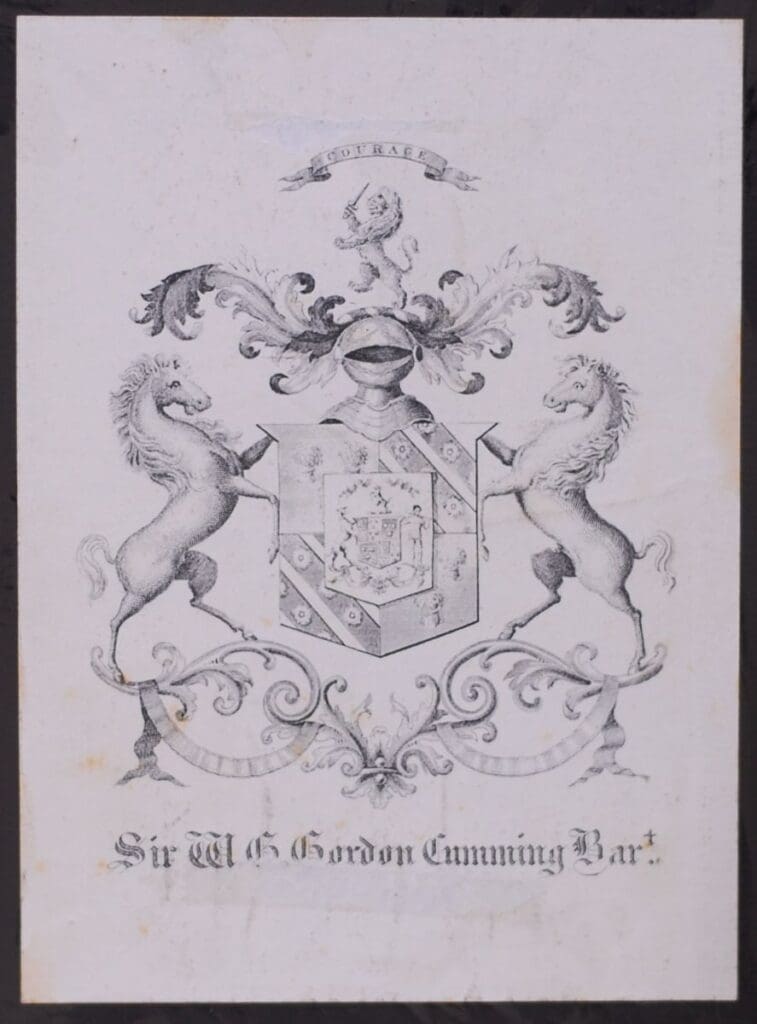
Bookplate of Gordon Cumming
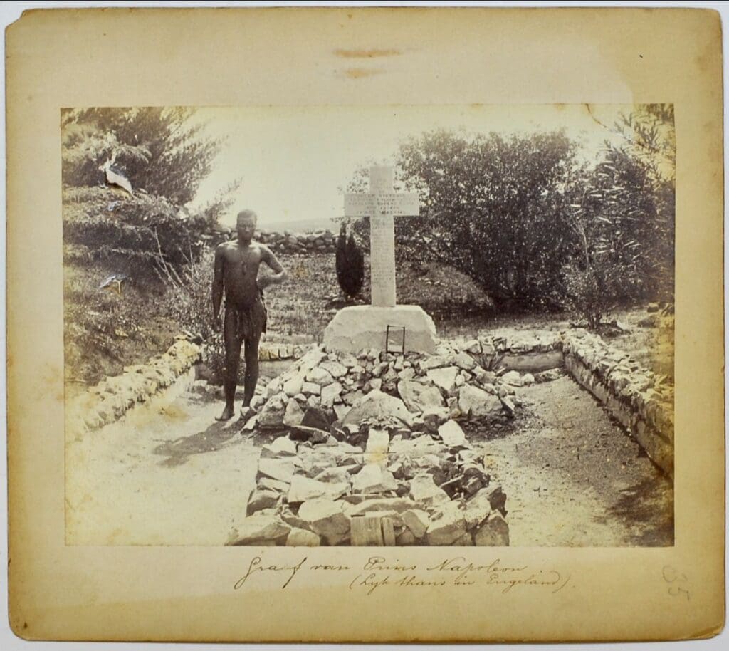
Photograph of the memorial where the Prince Imperial fell